
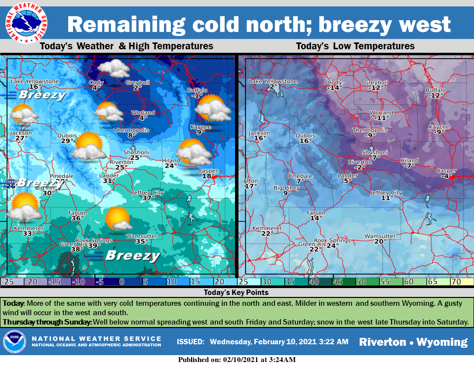
Weather Story
Remaining very cold in the north and east with clouds and some sunshine. Breezy and milder across western and southern Wyoming. A cold front will drop southward Thursday and spread very cold temperatures further south. Snow returning to the west late Thursday through at least Friday night.
– Detailed Forecast –
Today
Mostly sunny, with a high near 38. Breezy, with a west southwest wind 14 to 22 mph, with gusts as high as 31 mph.
Tonight
Mostly clear, with a low around 24. Breezy, with a west southwest wind 14 to 16 mph, with gusts as high as 23 mph.
Thursday
Partly sunny, with a high near 37. Breezy, with a west wind 16 to 22 mph, with gusts as high as 31 mph.
Thursday Night
A 20 percent chance of snow after 11pm. Mostly cloudy, with a low around 25. Southwest wind 10 to 14 mph, with gusts as high as 20 mph.
Friday
A 40 percent chance of snow. Mostly cloudy, with a high near 37. Breezy, with a west wind 10 to 15 mph increasing to 16 to 21 mph in the afternoon. Winds could gust as high as 29 mph. New snow accumulation of less than a half inch possible.
Friday Night
A 30 percent chance of snow, mainly before 11pm. Mostly cloudy, with a low around 8. Breezy, with a west wind 14 to 18 mph, with gusts as high as 25 mph.
Saturday
A 30 percent chance of snow showers after 11am. Mostly cloudy, with a high near 32. Northwest wind 11 to 13 mph becoming east northeast in the morning. Winds could gust as high as 21 mph.
Saturday Night
A 50 percent chance of snow showers. Mostly cloudy, with a low around 1.
Sunday
A 30 percent chance of snow showers, mainly before 11am. Mostly cloudy, with a high near 13.
Sunday Night
A 30 percent chance of snow showers. Mostly cloudy, with a low around -8.
Monday
Mostly cloudy, with a low around -2.
Monday Night
A slight chance of snow showers. Mostly cloudy, with a low around 16. Breezy.
Tuesday
Partly sunny, with a high near 34. Breezy.
Whatever the weather, have a wonderful day!
From all of us here at SweetwaterNOW

