
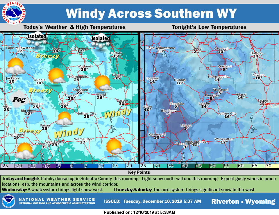
Weather Story
Light snow in the north will end this morning as will valley fog. Expect breezy to windy conditions in the mountains and across southern WY. Temperatures will warm slightly through the week, but a strong system will bring more snow and a cold front beginning Thursday.
– Detailed Forecast –
Today
Mostly cloudy, with a high near 30. Breezy, with a west wind 16 to 22 mph, with gusts as high as 32 mph.
Tonight
Mostly cloudy, with a low around 12. Wind chill values as low as zero. Southwest wind 7 to 13 mph.
Wednesday
Mostly cloudy, with a high near 29. West southwest wind 6 to 8 mph.
Wednesday Night
Mostly cloudy, with a low around 18. West southwest wind 8 to 10 mph.
Thursday
Mostly cloudy, with a high near 33. Southwest wind 7 to 11 mph.
Thursday Night
A 20 percent chance of snow after 11pm. Mostly cloudy, with a low around 25. West southwest wind 11 to 13 mph.
Friday
A 40 percent chance of snow. Partly sunny, with a high near 34. Breezy, with a west wind 11 to 15 mph, with gusts as high as 23 mph.
Friday Night
A 20 percent chance of snow. Mostly cloudy, with a low around 16. Breezy.
Saturday
A 30 percent chance of snow. Mostly cloudy, with a high near 27.
Saturday Night
A 30 percent chance of snow, mainly before 11pm. Mostly cloudy, with a low around 10.
Sunday
AA chance of snow. Partly sunny, with a high near 20.
Sunday Night
Partly cloudy, with a low around -1.
Monday
Mostly sunny, with a high near 22.
Whatever the weather, have a wonderful day!
From all of us here at SweetwaterNOW

