
Weather Story
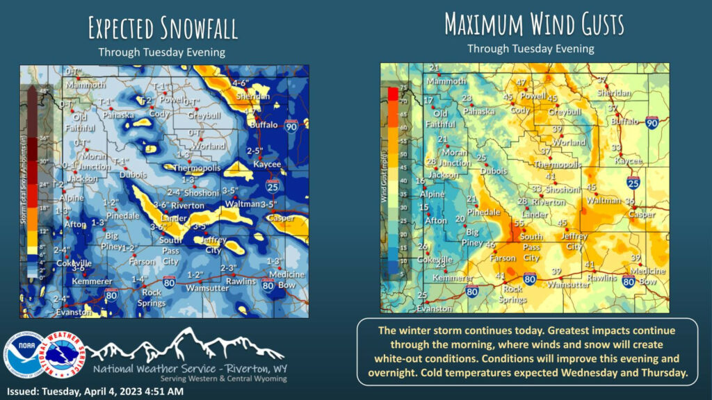
A winter storm has begun. Snow will spread across much of Wyoming today, with the heaviest snow expected for much of the central and southern regions. Snow rates will increase this afternoon, along with increasing wind. Together, white-out conditions likely. Greatest impacts will be this afternoon through Tuesday morning. Be safe out there!
– Detailed Forecast –
Today
Snow showers, mainly before 11am. Widespread blowing snow. High near 24. Windy, with a north northeast wind 20 to 28 mph, with gusts as high as 39 mph. Chance of precipitation is 90%. New snow accumulation of 1 to 3 inches possible.
Tonight
Scattered snow showers, mainly before 2am. Widespread blowing snow before 7pm. Mostly cloudy, with a low around 12. Blustery, with an east southeast wind 11 to 16 mph decreasing to 5 to 10 mph after midnight. Winds could gust as high as 23 mph. Chance of precipitation is 40%. New snow accumulation of less than a half inch possible.
Wednesday
Partly sunny, with a high near 28. Breezy, with an east southeast wind 5 to 15 mph becoming west northwest in the afternoon. Winds could gust as high as 21 mph.
Wednesday Night
Mostly clear, with a low around 9. Breezy, with a west southwest wind 8 to 15 mph, with gusts as high as 21 mph.
Thursday
Sunny, with a high near 31. West southwest wind 6 to 8 mph.
Thursday Night
Mostly clear, with a low around 10. West southwest wind 5 to 8 mph becoming south after midnight.
Friday
Mostly sunny, with a high near 35.
Friday Night
Mostly cloudy, with a low around 20.
Saturday
Partly sunny, with a high near 40.
Saturday Night
Mostly cloudy, with a low around 27.
Sunday
Mostly sunny, with a high near 43.
Sunday Night
Partly cloudy, with a low around 28.
Monday
Mostly sunny, with a high near 47.
Whatever the weather, have a wonderful day!
From all of us here at SweetwaterNOW

