
Weather Story
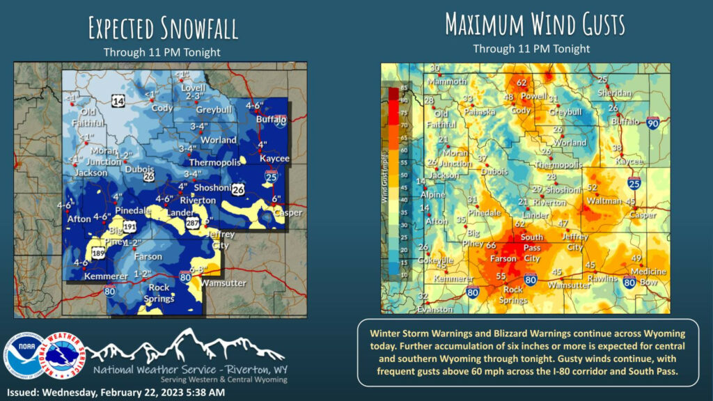
Winter Storm and Blizzard Warnings continue through tonight. Moderate to heavy snow is expected today, which will be hampered by very gusty winds. Some areas along I-80 and South Pass will see continued gusts above 60 mph today.
– Detailed Forecast –
Today
Snow, mainly before 4pm. Widespread blowing snow, mainly before 3pm. Temperature falling to around 0 by 11am. Wind chill values as low as -25. Very windy, with an east wind 31 to 36 mph decreasing to 21 to 26 mph in the afternoon. Winds could gust as high as 55 mph. Chance of precipitation is 100%. Total daytime snow accumulation of 1 to 2 inches possible.
Tonight
A 30 percent chance of snow, mainly before 2am. Mostly cloudy, with a low around -13. Wind chill values as low as -25. Breezy, with an east wind 7 to 17 mph becoming north after midnight. Winds could gust as high as 26 mph.
Thursday
Partly sunny, with a high near 20. Wind chill values as low as -25. Breezy, with a north northeast wind 5 to 10 mph becoming south 11 to 16 mph in the afternoon. Winds could gust as high as 24 mph.
Thursday Night
Mostly cloudy, with a low around 1. South southeast wind 5 to 8 mph.
Friday
Partly sunny, with a high near 25. South southeast wind 5 to 7 mph becoming west southwest in the afternoon.
Friday Night
Partly cloudy, with a low around 2. South wind around 7 mph.
Saturday
Mostly sunny, with a high near 28. South wind around 7 mph becoming northwest in the afternoon.
Saturday Night
Mostly cloudy, with a low around 8.
Sunday
Partly sunny, with a high near 31.
Sunday Night
Mostly cloudy, with a low around 13. Breezy.
Monday
Mostly sunny, with a high near 32. Breezy.
Monday Night
Mostly cloudy, with a low around 12.
Tuesday
A chance of snow. Partly sunny, with a high near 32.
Whatever the weather, have a wonderful day!
From all of us here at SweetwaterNOW

