
Weather Story
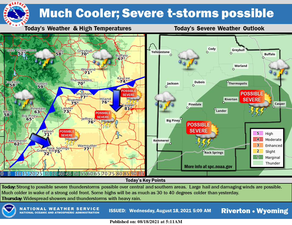
A strong cold front has pushed into western and northern Wyoming early this morning. This cold front will slowly push across the rest of the area today. Much colder temperatures in wake of the cold front. Some locations will be 30 to 40 degrees colder than yesterday. Strong to severe thunderstorms could occur especially over central and southern areas this afternoon and evening. Large hail (around 1″ in diameter) and damaging winds above 50 mph could occur in the strongest storms. Locally heavy rainfall is also possible.
– Detailed Forecast –
Today
Showers likely before 9am, then showers likely and possibly a thunderstorm between 9am and 11am, then a chance of showers and thunderstorms after 11am. Some of the storms could produce small hail and gusty winds. Mostly cloudy, with a high near 74. Breezy, with a south southwest wind 13 to 17 mph, with gusts as high as 26 mph. Chance of precipitation is 60%. New rainfall amounts between a tenth and quarter of an inch, except higher amounts possible in thunderstorms.
Tonight
Showers and thunderstorms before 10pm, then showers likely and possibly a thunderstorm between 10pm and 3am, then a chance of showers and thunderstorms after 3am. Some of the storms could produce small hail and gusty winds. Low around 52. West southwest wind 8 to 14 mph becoming east southeast in the evening. Winds could gust as high as 21 mph. Chance of precipitation is 80%. New rainfall amounts between a quarter and half of an inch possible.
Thursday
A chance of showers and thunderstorms before 9am, then showers likely and possibly a thunderstorm between 9am and 3pm, then a chance of showers and thunderstorms after 3pm. Some of the storms could produce small hail and gusty winds. Mostly cloudy, with a high near 60. West southwest wind 10 to 14 mph, with gusts as high as 20 mph. Chance of precipitation is 70%.
Thursday Night
A chance of showers and thunderstorms. Mostly cloudy, with a low around 44. West southwest wind 10 to 14 mph, with gusts as high as 22 mph. Chance of precipitation is 40%.
Friday
A 30 percent chance of showers, mainly before noon. Partly sunny, with a high near 68. Breezy, with a west wind 10 to 15 mph, with gusts as high as 23 mph.
Friday Night
Mostly clear, with a low around 46. West wind 6 to 11 mph becoming south southeast after midnight.
Saturday
Mostly sunny, with a high near 75. Breezy.
Saturday Night
A chance of showers and thunderstorms. Partly cloudy, with a low around 50. Chance of precipitation is 30%.
Sunday
A slight chance of showers, then a chance of showers and thunderstorms after noon. Mostly sunny, with a high near 75. Breezy. Chance of precipitation is 30%.
Sunday Night
Mostly clear, with a low around 50.
Monday
Sunny, with a high near 83. Breezy.
Monday Night
Mostly clear, with a low around 51.
Tuesday
Sunny, with a high near 81.
Whatever the weather, have a wonderful day!
From all of us here at SweetwaterNOW

