
Weather Story
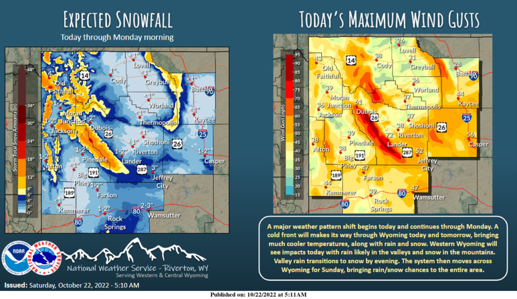
A big weather shift starts today. Rain and snow chances for western Wyoming begin today, with chances spreading to the rest of the area for Sunday. Gusty winds will also be expected ahead of a cold front, which brings in much cooler temperatures for Sunday.
– Detailed Forecast –
Today
Rain likely, mainly after 5pm. Mostly cloudy, with a high near 55. Windy, with a west southwest wind 20 to 26 mph, with gusts as high as 37 mph. Chance of precipitation is 70%.
Tonight
Rain before midnight, then snow. Low around 33. Breezy, with a west wind 17 to 22 mph becoming west southwest 7 to 12 mph after midnight. Winds could gust as high as 29 mph. Chance of precipitation is 90%. New snow accumulation of less than one inch possible.
Sunday
Sunny, with a high near 65. Windy, with a west wind 9 to 14 mph increasing to 20 to 25 mph in the afternoon. Winds could gust as high as 38 mph.
Sunday Night
Scattered snow showers. Mostly cloudy, with a low around 20. Breezy, with a west wind 10 to 16 mph, with gusts as high as 26 mph. Chance of precipitation is 50%. New snow accumulation of less than one inch possible.
Monday
Mostly sunny, with a high near 40. Breezy, with a west wind 13 to 20 mph, with gusts as high as 32 mph.
Monday Night
Mostly cloudy, with a low around 24. Breezy, with a west southwest wind 14 to 20 mph, with gusts as high as 31 mph.
Tuesday
Partly sunny, with a high near 43. Breezy, with a west wind 14 to 18 mph, with gusts as high as 29 mph.
Tuesday Night
Mostly cloudy, with a low around 22.
Wednesday
Scattered snow showers, mainly after noon. Mostly cloudy, with a high near 43. Chance of precipitation is 30%.
Wednesday Night
Scattered snow showers. Mostly cloudy, with a low around 22. Chance of precipitation is 40%.
Thursday
Isolated snow showers. Partly sunny, with a high near 39.
Thursday Night
Mostly clear, with a low around 18.
Friday
Mostly sunny, with a high near 43.
Whatever the weather, have a wonderful day!
From all of us here at SweetwaterNOW

