
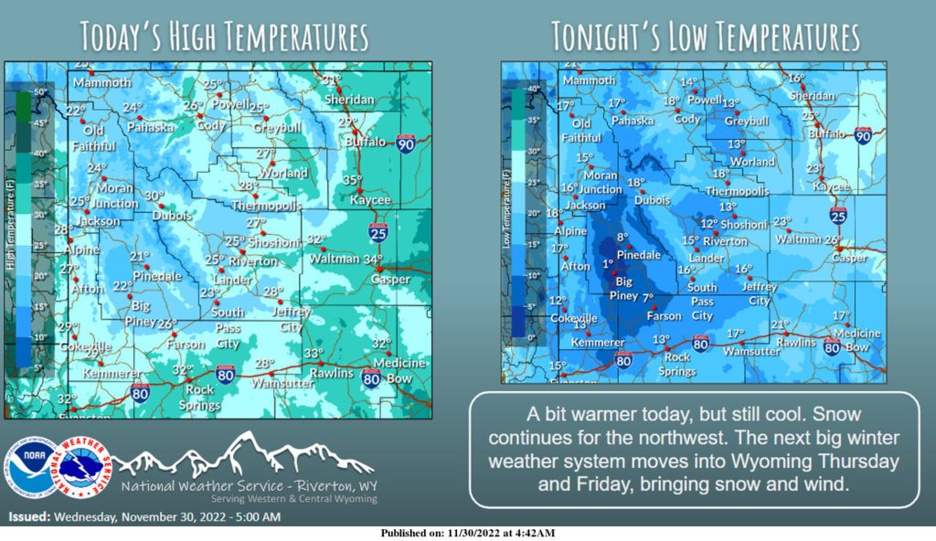
Weather Story
Temperatures will be a little warmer today, but still well below average. Snow continues for the northwest through the day. A weather system enters western Wyoming Thursday, bringing significant snow for the west, with light snow chances elsewhere. Strong winds ahead of the system likely. This system will impact through Friday night.
– Detailed Forecast –
Today
Partly sunny, with a high near 30. Wind chill values as low as -5. Northeast wind 5 to 7 mph becoming calm in the afternoon.
Tonight
Mostly clear, with a low around 13. South southwest wind 5 to 8 mph becoming light and variable after midnight
Thursday
Mostly sunny, with a high near 38. Windy, with a light southwest wind becoming south 27 to 32 mph in the morning. Winds could gust as high as 43 mph.
Thursday Night
Scattered snow showers after 11pm. Mostly cloudy, with a low around 21. Breezy, with a south wind 14 to 21 mph, with gusts as high as 30 mph. Chance of precipitation is 40%. New snow accumulation of less than a half inch possible.
Friday
Snow showers likely before 11am. Partly sunny, with a high near 30. Breezy, with a west wind 22 to 24 mph, with gusts as high as 39 mph. Chance of precipitation is 60%. New snow accumulation of less than one inch possible.
Friday Night
Partly cloudy, with a low around 3. Breezy, with a west wind 15 to 20 mph becoming south southwest 8 to 13 mph after midnight. Winds could gust as high as 30 mph.
Saturday
Mostly sunny, with a high near 23. South southeast wind around 7 mph.
Saturday Night
Mostly cloudy, with a low around 11.
Sunday
Isolated snow showers. Mostly cloudy, with a high near 30. Chance of precipitation is 20%.
Sunday Night
Isolated snow showers. Mostly cloudy, with a low around 13. Chance of precipitation is 20
Monday
Isolated snow showers. Partly sunny, with a high near 26. Breezy.
Monday Night
Partly cloudy, with a low around 8. Breezy.
Tuesday
Mostly sunny, with a high near 24. Breezy.
Whatever the weather, have a wonderful day!
From all of us here at SweetwaterNOW

