
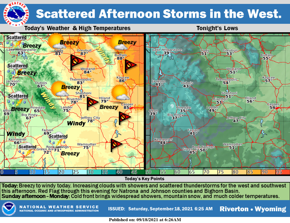
Weather Story
Red Flag Warnings are in effect for noon to 8 PM today. Showers and thunderstorms will move into the west and southwest this afternoon and evening. Cold front on Sunday will bring rain, mountain snow, gusty winds and much colder temperatures for Monday and Tuesday.
– Detailed Forecast –
Today
Scattered showers, with thunderstorms also possible after 4pm. Increasing clouds, with a high near 70. Breezy, with a light south wind becoming west southwest 17 to 22 mph in the afternoon. Winds could gust as high as 33 mph. Chance of precipitation is 50%.
Tonight
Scattered showers and thunderstorms before 9pm. Mostly cloudy during the early evening, then gradual clearing, with a low around 47. Breezy, with a south southwest wind 10 to 16 mph, with gusts as high as 24 mph. Chance of precipitation is 40%.
Sunday
Increasing clouds, with a high near 71. Breezy, with a south southwest wind 11 to 16 mph increasing to 19 to 24 mph in the afternoon. Winds could gust as high as 37 mph.
Sunday Night
A chance of showers between 7pm and 1am. Mostly cloudy, with a low around 34. Windy, with a west wind 20 to 25 mph decreasing to 13 to 18 mph after midnight. Winds could gust as high as 38 mph. Chance of precipitation is 30%.
Monday
A 20 percent chance of showers after 1pm. Mostly sunny, with a high near 56. West wind 11 to 14 mph, with gusts as high as 26 mph.
Monday Night
A 20 percent chance of showers before 7pm. Mostly clear, with a low around 34. Northwest wind 5 to 14 mph, with gusts as high as 26 mph.
Tuesday
Sunny, with a high near 65. Light southwest wind becoming west 8 to 13 mph in the morning.
Tuesday Night
Mostly clear, with a low around 37.
Wednesday
Sunny, with a high near 73.
Wednesday Night
Mostly clear, with a low around 38.
Thursday
Mostly sunny, with a high near 71.
Thursday Night
Partly cloudy, with a low around 40.
Friday
Sunny, with a high near 71.
Whatever the weather, have a wonderful day!
From all of us here at SweetwaterNOW

