
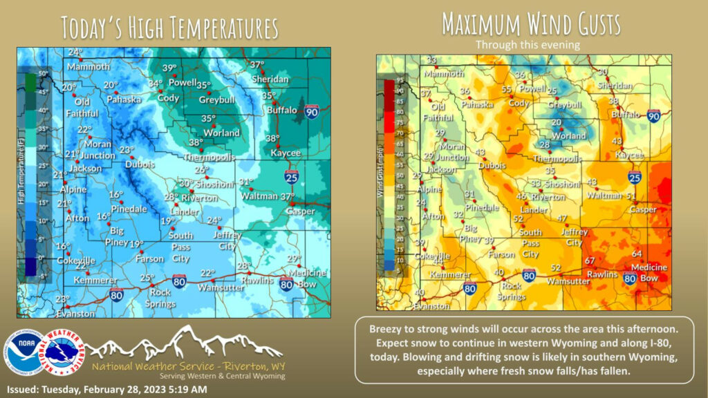
Weather Story
Snow continues across western and southern Wyoming. Heavy snow bands are possible early this morning along I-80, with greatly reduced visibility due to falling and blowing snow. It will be breezy to windy across the area this afternoon.
– Detailed Forecast –
Today
A 30 percent chance of snow showers, mainly before 10am. Mostly cloudy, then gradually becoming sunny, with a steady temperature around 20. Wind chill values as low as zero. Windy, with a west wind 17 to 22 mph increasing to 25 to 30 mph in the morning. Winds could gust as high as 40 mph.
Tonight
Partly cloudy, with a low around 1. Wind chill values as low as -5. West southwest wind 5 to 11 mph becoming northeast in the evening.
Wednesday
A 40 percent chance of snow showers, mainly after 9am. Mostly cloudy, with a high near 29. Wind chill values as low as -5. East northeast wind 7 to 14 mph becoming south southwest in the afternoon. New snow accumulation of less than one inch possible.
Wednesday Night
Mostly cloudy, with a low around 5. East northeast wind 6 to 9 mph becoming northwest after midnight.
Thursday
Mostly sunny, with a high near 26. Breezy, with a west wind 6 to 11 mph increasing to 17 to 22 mph in the afternoon. Winds could gust as high as 33 mph.
Thursday Night
Partly cloudy, with a low around 8. Windy, with a west wind 20 to 25 mph decreasing to 14 to 19 mph after midnight. Winds could gust as high as 38 mph.
Friday
Mostly sunny, with a high near 26. Windy
Friday Night
Mostly clear, with a low around 0. Breezy.
Saturday
Mostly sunny, with a high near 26.
Saturday Night
Partly cloudy, with a low around 8.
Sunday
Mostly sunny, with a high near 31.
Sunday Night
Mostly cloudy, with a low around 11.
Monday
Partly sunny, with a high near 31.
Whatever the weather, have a wonderful day!
From all of us here at SweetwaterNOW

