
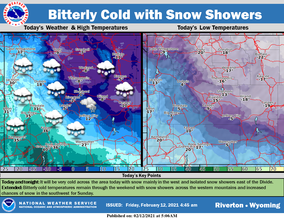
Weather Story
Well below average temperatures will continue today and last through the weekend. Snow showers will be likely in the western mountains with isolated showers possible east of the Divide. Snow showers continue into the weekend.
– Detailed Forecast –
Today
Snow showers likely, mainly before 3pm. Mostly cloudy, with a high near 36. Breezy, with a west wind 11 to 18 mph, with gusts as high as 28 mph. Chance of precipitation is 70%. New snow accumulation of around an inch possible.
Tonight
Scattered snow showers, mainly between 8pm and 9pm. Mostly cloudy, with a low around 18. Breezy, with a west wind 11 to 18 mph, with gusts as high as 29 mph. Chance of precipitation is 30%.
Saturday
Snow showers, mainly after 8am. High near 29. Blustery, with a north wind 8 to 16 mph becoming southeast in the morning. Winds could gust as high as 24 mph. Chance of precipitation is 80%. New snow accumulation of 1 to 3 inches possible.
Saturday Night
Scattered snow showers, mainly before 11pm. Patchy blowing snow before 9pm. Mostly cloudy, with a low around -4. Blustery, with an east northeast wind 17 to 23 mph, with gusts as high as 34 mph. Chance of precipitation is 50%. New snow accumulation of less than one inch possible.
Sunday
Partly sunny and cold, with a high near 10. Blustery, with an east northeast wind 8 to 15 mph, with gusts as high as 23 mph.
Sunday Night
A 20 percent chance of snow after 11pm. Mostly cloudy, with a low around -1. East wind 5 to 7 mph becoming light and variable.
Monday
A 20 percent chance of snow. Partly sunny, with a high near 27.
Monday Night
A 30 percent chance of snow before 11pm. Mostly cloudy, with a low around 17. Breezy.
Tuesday
A 20 percent chance of snow before 11am. Mostly sunny, with a high near 31. Breezy.
Tuesday Night
Mostly cloudy, with a low around 10. Breezy.
Wednesday
Partly sunny, with a high near 29.
Wednesday Night
Partly cloudy, with a low around 5.
Thursday
Mostly sunny, with a high near 30.
Whatever the weather, have a wonderful day!
From all of us here at SweetwaterNOW

