
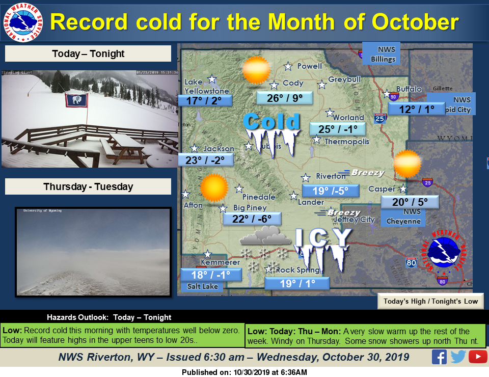
Record cold weather with many temperatures below zero this morning. Dangerous wind chill readings fom Rock Springs to Casper this morning. Sunny and cold today with highs mainly in the upper teens to low 20s. Thursday will be windy and milder with high temperatures breaking freezing in many areas. Some showers are possible with a clipper type system in northern Wyoming Thursday night.
Detailed Forecast
Today
Sunny, with a high near 20. Wind chill values as low as -30. Breezy, with a west southwest wind 8 to 13 mph increasing to 17 to 22 mph in the afternoon. Winds could gust as high as 33 mph.
Tonight
Clear, with a low around 2. Wind chill values as low as -15. Breezy, with a west southwest wind 17 to 22 mph decreasing to 11 to 16 mph after midnight. Winds could gust as high as 33 mph.
Thursday
Sunny, with a high near 30. Wind chill values as low as -15. Breezy, with a southwest wind 9 to 14 mph increasing to 18 to 23 mph in the afternoon. Winds could gust as high as 34 mph.
Thursday Night
Partly cloudy, with a low around 7. West wind 7 to 9 mph.
Friday
Sunny, with a high near 30. West wind around 6 mph becoming northeast in the morning.
Friday Night
Mostly clear, with a low around 6. Southwest wind around 6 mph.
Saturday
Sunny, with a high near 36.
Saturday Night
Mostly clear, with a low around 14.
Sunday
Sunny, with a high near 41.
Sunday Night
Partly cloudy, with a low around 21.
Monday
Mostly sunny, with a high near 42. Breezy.
Monday Night
Partly cloudy, with a low around 19.
Tuesday
Mostly sunny, with a high near 43.
Advertisement - Story continues below...

