
Weather Story
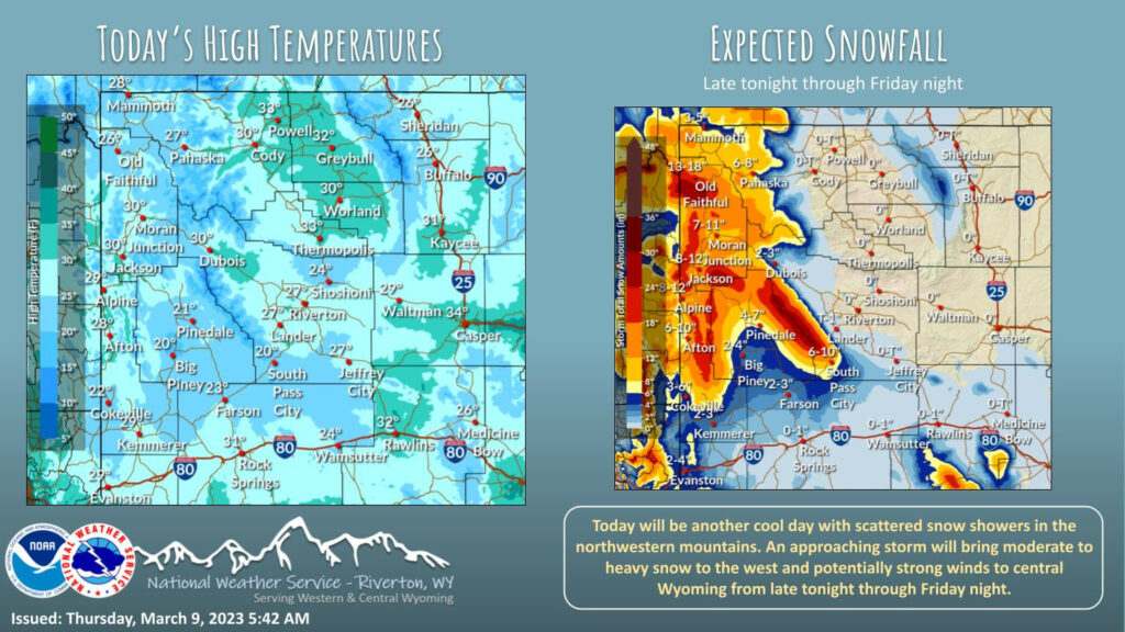
Other than a few snow showers in northwest Wyoming, expect a dry and cool day today. A potent Pacific Storm will bring moderate to heavy snow to western Wyoming Friday with strong to potentially high winds to portions of central Wyoming.
– Detailed Forecast –
Today
Patchy fog before 11am. Otherwise, sunny, with a high near 29. Wind chill values as low as -5. Breezy, with a west wind 10 to 17 mph, with gusts as high as 26 mph.
Tonight
Mostly cloudy, with a low around 12. South southwest wind 6 to 8 mph.
Friday
A chance of snow showers before 3pm, then a chance of rain and snow showers between 3pm and 5pm, then a chance of rain showers after 5pm. Mostly cloudy, with a high near 38. Wind chill values as low as zero. Breezy, with a south wind 8 to 15 mph, with gusts as high as 23 mph. Chance of precipitation is 50%. New snow accumulation of less than a half inch possible.
Friday Night
Rain showers likely before 7pm, then rain and snow showers likely between 7pm and 10pm, then snow showers likely after 10pm. Mostly cloudy, with a low around 21. Breezy, with a southwest wind 15 to 20 mph, with gusts as high as 30 mph. Chance of precipitation is 60%. New snow accumulation of less than one inch possible.
Saturday
Mostly sunny, with a high near 32. West wind 11 to 14 mph, with gusts as high as 21 mph.
Saturday Night
Partly cloudy, with a low around 10. West southwest wind 6 to 8 mph.
Sunday
Mostly sunny, with a high near 31. West wind 6 to 10 mph.
Sunday Night
Mostly cloudy, with a low around 17.
Monday
Partly sunny, with a high near 36.
Monday Night
Mostly cloudy, with a low around 21.
Tuesday
A chance of rain and snow showers. Partly sunny, with a high near 41.
Tuesday Night
A chance of snow showers. Mostly cloudy, with a low around 27. Breezy.
Wednesday
A chance of snow showers. Partly sunny, with a high near 37. Breezy.
Whatever the weather, have a wonderful day!
From all of us here at SweetwaterNOW