
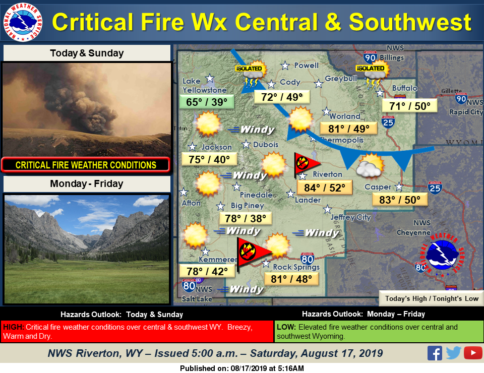
Critical fire weather conditions (windy with low relative humidity) will occur over much of central and southern Wyoming each afternoon and evening today and Sunday. A cold front will push south, east of the Divide today into this evening. Some showers and a very isolated thunderstorm will be possible over the north.
Detailed Forecast
Today
Sunny, with a high near 82. Windy, with a west wind 7 to 17 mph increasing to 18 to 28 mph in the afternoon. Winds could gust as high as 41 mph.
Tonight
Clear, with a low around 48. Windy, with a west wind 16 to 26 mph decreasing to 6 to 16 mph after midnight. Winds could gust as high as 40 mph.
Advertisement - Story continues below...
Sunday
Sunny, with a high near 86. Breezy, with a west wind 6 to 11 mph increasing to 16 to 21 mph in the afternoon. Winds could gust as high as 31 mph.
Sunday Night
Mostly clear, with a low around 50. Breezy, with a west wind 12 to 17 mph becoming southwest 5 to 10 mph after midnight. Winds could gust as high as 24 mph.
Monday
Sunny, with a high near 88. Southwest wind 6 to 11 mph.
Monday Night
Mostly clear, with a low around 51. West wind 5 to 11 mph.
Tuesday
Sunny, with a high near 87. Light and variable wind becoming north northeast 5 to 7 mph in the afternoon.
Tuesday Night
Mostly clear, with a low around 51.
Wednesday
Sunny, with a high near 87.
Wednesday Night
Partly cloudy, with a low around 51.
Thursday
Sunny, with a high near 87.
Thursday Night
Mostly clear, with a low around 52.
Friday
Sunny, with a high near 86.

