SWEETWATER COUNTY — More discussions took place during the Sweetwater County Commission meeting regarding the proposed boundary adjustment of the Buckboard Marina.
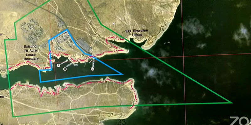
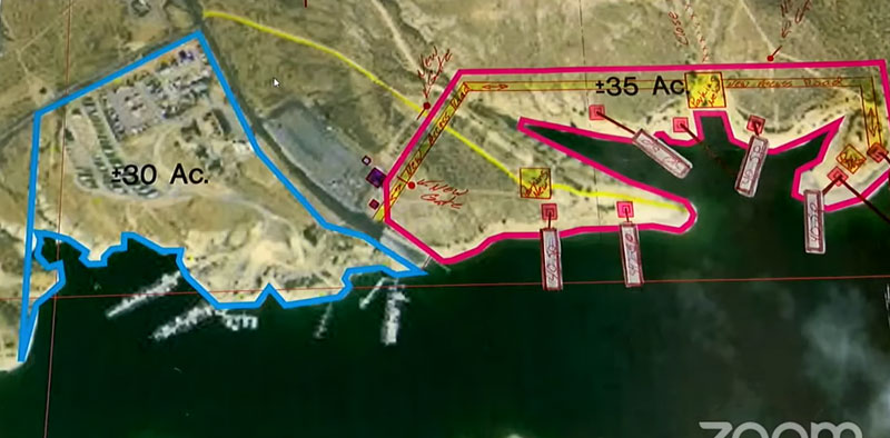
The boundary adjustment would be to the marina’s special use permit which would transfer acreage that currently exists in the water to land surrounding the marina. Tony and Jennifer Valdez are the current permittees.
The Ashley National Forest previously extended the public scoping period from April 21 to May 19 following concerns expressed during the April 18 Commission meeting. The Commission filed a Freedom of Information Act (FOIA) request to get access to the permit for further information on this proposal.
However, the County Commission said they just received their FOIA request this week so they feel they are still put into a short time frame to review the information and address public concerns.
In a 4-0 vote, the Commission approved for Sweetwater County Land Use Director Eric Bingham to draft a letter indicating that the Commission would prefer that the process for this boundary change go through the National Environmental Policy Act (NEPA) process. Commissioner Lauren Schoenfeld was absent during the vote.
According to the United States Department of Energy, “using the NEPA process, agencies are required to determine if their proposed actions have significant environmental effects and to consider the environmental and related social and economic effects of their proposed actions.”
Commissioner Island Richards said he was confused over what the Commission’s role is supposed to be in this process, as usually they would be a cooperating agency. However, due to the lack of notice and information given by the Forest Service, Richards said they are more of a “commenting entity”.
“Typically, we would be considered a cooperating entity through a NEPA process, but they have kind of forestalled that and jumped ahead of that. I think that’s probably what our comments should reflect. I don’t know enough about this plan to say yes or no and it’s because we didn’t go through a discovery process that we would typically go through so we would have the information to make good decisions as a cooperating agency,” Richards said.
Bingham noted that there is a statement in the Coalition of Local Governments (CLG) regulations that says federal, local, and state governments should receive adequate notice and an opportunity to comment upon a special use proposal accepted as formal application in accordance with the forest service procedures.
“I guess that’s our first concern is that we were not provided, like we do in other projects where we have a project scoping period, we were not provided sufficient time to actually comment. I feel like we’re rushed right now trying to get these comments together and get more information,” Bingham said.
He added, “If I don’t get confirmation on extending this time for the county to get those comments out, then we’re in the position that we would ask them to go through an environmental assessment so they can analyze some of these concerns that have been brought up.”
Lack of Information and Communication
County resident concerns are primarily regarding worries that public access to the land surrounding the marina will be reduced. However, Bingham said the existing boundary already includes a “buffer zone” which is an area around the existing boundary where camping is not allowed.
Bingham assumes the zone has always been in place, but just has not been enforced. He said the buffer boundary is determined by the Forest Service. Commissioner Robb Slaughter said this is the first he’s ever heard of the buffer zone, and that the public is hearing the land transfer will make it so they can no longer recreate on South Buckboard.
“That’s not the case. What we’re doing is applying the law that’s been in place for a long time and actually using that law at this time. But the public needs to understand that and they don’t so we need to go through this process,” Slaughter said.
Commissioner Mary Thoman said that while she believes a NEPA process would be good, she worries that many of the complaints are due to misinformation.
“We do have constituent complaints, and I’m a little distressed that some of them maybe are not accurate,” Thoman said.
Other complaints include the lack of services being offered at the marina such as fuel. Bingham said the reason for the lack of fuel sales since the Valdez family took over the marina is because of the cost of new fuel tanks. He said the previous tanks were noncompliant as determined by the Department of Environmental Quality (DEQ) so they had to be removed. The new tanks are $280,000.
“There is that issue of that huge cost,” Bingham said. “I know the owners looked at grants, I’m not aware of any federal grant that would be applicable in this situation.”
He added that Sweetwater County Grants Manager Krisena Marchal does not know of any grants either. Commissioner Thoman said there is fuel out there, but they have to take the boats out of the water to use the tanks.
Work in Progress
Jennifer Valdez was present at the meeting via Zoom and she provided a few words to try to ease some concerns.
“We are a work in progress, we’ve been very forthcoming in that,” Valdez said.
Valdez said she and her family are working on providing more services. She also noted that they do not want to keep the public off the land, but that they do want to provide a safe place for those who live out by the marina.
“We’re not trying to keep the public out, we do depend on the public to make a living. But we also have customers that live here temporarily or longer term that we do need to ensure have a safe place to stay, and enjoyable and quiet,” Valdez said.
The comments were made in response to concerns raised by resident Greg Tanner regarding alleged statements by law enforcement about shutting off access to camping spots near the marina. Tanner said there are other areas where the Valdez family could make private access for renters, but to take South Buckboard is wrong.
Commissioner Thoman said the Valdez’s have a lease for the marina and the land within the boundary and they are allowed to develop the business how they want.
“You can’t blame [Tony Valdez] for wanting to improve the aesthetics of the area either,” Thoman said, adding that it’s a “trash pile” on the south side of Buckboard.
Thoman also said Tony and his family are only asking for two miles of shoreline.
“There’s 370 miles of shoreline, and 175 miles are in Wyoming. He’s asking for less than two miles of shoreline,” she said.
Commissioner Richards said he wants to see the Valdez family grow the marina into a great facility, but that the boundary adjustment needs to follow a public process. The Commission are currently awaiting word on whether or not the Forest Service will accept their request for this proposal to go through a NEPA process.