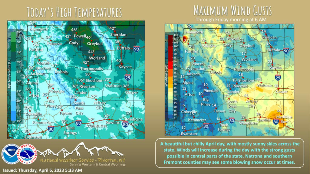

Weather Story
The unseasonable cold remains over the area, with temperatures feeling more like February than April. Winds will increase during the day with some strong gusts developing over central parts of the state. Southern Fremont and Natrona Counties may see some blowing snow due to these winds and newly fallen snow.
– Detailed Forecast –
Today
Isolated snow showers after noon. Patchy blowing snow after 3pm. Partly sunny, with a high near 28. Breezy, with a south southeast wind 6 to 11 mph becoming west 12 to 17 mph in the afternoon. Winds could gust as high as 24 mph. Chance of precipitation is 20%.
Tonight
Isolated snow showers before 9pm. Patchy blowing snow before 7pm. Partly cloudy, with a low around 10. Wind chill values as low as zero. Breezy, with a south southwest wind 9 to 17 mph, with gusts as high as 24 mph. Chance of precipitation is 20%.
Thursday
Sunny, with a high near 31. Wind chill values as low as -5. West southwest wind 7 to 10 mph.
Thursday Night
Mostly clear, with a low around 11. West southwest wind around 6 mph becoming light and variable after midnight.
Friday
Mostly sunny, with a high near 38. South wind 3 to 6 mph.
Friday Night
Mostly cloudy, with a low around 21. South southwest wind around 6 mph.
Saturday
Partly sunny, with a high near 41. South southwest wind 6 to 9 mph.
Saturday Night
Mostly cloudy, with a low around 25.
Sunday
Mostly sunny, with a high near 43.
Sunday Night
Partly cloudy, with a low around 29.
Monday
Mostly sunny, with a high near 51.
Monday Night
Partly cloudy, with a low around 32.
Tuesday
Sunny, with a high near 51.
Whatever the weather, have a wonderful day!
From all of us here at SweetwaterNOW