
Weather Story
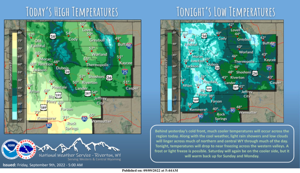
Much cooler today. Clouds and rain showers will continue across the north and central areas through this evening. Across the west will remain mostly dry. Freezing temperatures are expected across the western valleys tonight. Saturday will be dry, but remaining cool. Warmer and dry to start the work week.
– Detailed Forecast –
Today
Areas of smoke. Sunny, with a high near 71. Breezy, with an east wind 8 to 15 mph becoming north in the afternoon. Winds could gust as high as 23 mph.
Tonight
Areas of smoke. Mostly clear, with a low around 44. Windy, with an east northeast wind 20 to 25 mph decreasing to 11 to 16 mph after midnight. Winds could gust as high as 38 mph.
Saturday
Sunny, with a high near 68. East northeast wind 10 to 14 mph, with gusts as high as 20 mph.
Saturday Night
Mostly clear, with a low around 38. East wind 5 to 10 mph.
Sunday
Sunny, with a high near 79. Light and variable wind becoming west 5 to 9 mph in the morning.
Sunday Night
Mostly clear, with a low around 45. West northwest wind 5 to 7 mph becoming south southwest in the evening.
Monday
Sunny, with a high near 81. West wind 5 to 11 mph.
Monday Night
Partly cloudy, with a low around 49.
Tuesday
A 30 percent chance of showers and thunderstorms after noon. Mostly cloudy, with a high near 75.
Tuesday Night
A chance of showers and thunderstorms. Mostly cloudy, with a low around 48. Chance of precipitation is 30%.
Wednesday
A chance of showers and thunderstorms. Partly sunny, with a high near 73.
Wednesday Night
A chance of showers. Mostly cloudy, with a low around 47.
Thursday
A chance of showers and thunderstorms. Mostly sunny, with a high near 75.
Whatever the weather, have a wonderful day!
From all of us here at SweetwaterNOW

