
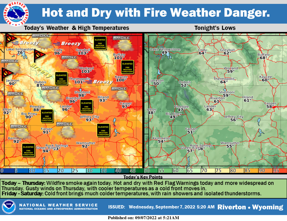
Weather Story
Hot and dry, with smoky skies today. Red Flag Warnings today will become more widespread on Thursday. This is due to a cold front approaching and bringing gusty winds. There will be rain showers and isolated thunderstorms, mainly east of the Divide for Thursday evening through early Saturday. Significant temperature drops on Thursday and Friday.
– Detailed Forecast –
Today
Areas of smoke. Sunny, with a high near 93. Light and variable wind becoming west southwest 8 to 13 mph in the afternoon.
Tonight
Areas of smoke. Mostly clear, with a low around 56. Southwest wind 6 to 14 mph, with gusts as high as 21 mph.
Thursday
Mostly sunny, with a high near 88. Breezy, with a west wind 5 to 10 mph increasing to 17 to 22 mph in the afternoon. Winds could gust as high as 32 mph.
Thursday Night
Mostly clear, with a low around 50. Breezy, with a west northwest wind 15 to 20 mph becoming north northeast 7 to 12 mph after midnight. Winds could gust as high as 29 mph.
Friday
Sunny, with a high near 75. East northeast wind 10 to 14 mph becoming west northwest in the afternoon. Winds could gust as high as 21 mph.
Friday Night
Mostly clear, with a low around 46. Breezy, with a northwest wind 11 to 20 mph becoming east northeast after midnight. Winds could gust as high as 29 mph.
Saturday
Sunny, with a high near 75. Breezy, with an east northeast wind 13 to 16 mph, with gusts as high as 25 mph.
Saturday Night
Mostly clear, with a low around 45.
Sunday
Sunny, with a high near 79.
Sunday Night
Partly cloudy, with a low around 51.
Monday
Mostly sunny, with a high near 80.
Monday Night
Mostly cloudy, with a low around 51.
Tuesday
A chance of showers and thunderstorms. Partly sunny, with a high near 73.
Whatever the weather, have a wonderful day!
From all of us here at SweetwaterNOW

