
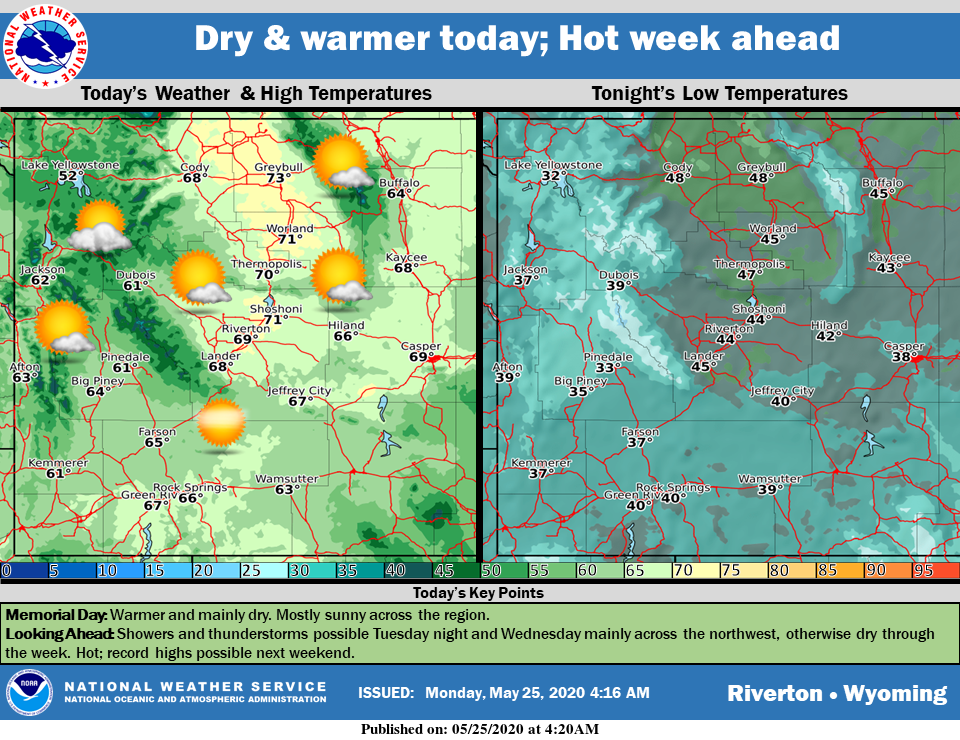
Weather Story
Warmer and mostly sunny for Memorial Day. Clouds increase in the northwest tonight and showers and thunderstorms are possible Tuesday night and Wednesday, mainly across the northwest. Otherwise, the rest of the week looks to be hot and mainly dry. Record highs are possible next weekend.
– Detailed Forecast –
Today
Sunny, with a high near 66. Light and variable wind becoming west northwest 6 to 11 mph in the morning.
Tonight
Mostly clear, with a low around 40. West northwest wind 7 to 13 mph becoming southwest after midnight.
Tuesday
Sunny, with a high near 72. Breezy, with a southwest wind 7 to 15 mph becoming west northwest in the afternoon. Winds could gust as high as 21 mph.
Tuesday Night
Partly cloudy, with a low around 44. Breezy, with a west northwest wind 6 to 16 mph, with gusts as high as 26 mph.
Wednesday
A slight chance of showers between noon and 3pm, then a slight chance of showers and thunderstorms after 3pm. Partly sunny, with a high near 75. Breezy, with a west wind 6 to 15 mph, with gusts as high as 26 mph. Chance of precipitation is 20%.
Wednesday Night
Mostly clear, with a low around 44. West northwest wind 6 to 14 mph becoming east northeast after midnight. Winds could gust as high as 26 mph.
Thursday
Sunny, with a high near 79. East northeast wind 5 to 7 mph becoming north in the afternoon.
Thursday Night
Mostly clear, with a low around 47
Friday
Sunny, with a high near 86.
Friday Night
Mostly clear, with a low around 48.
Saturday
Mostly sunny, with a high near 86.
Saturday Night
Mostly cloudy, with a low around 48.
Sunday
Mostly sunny, with a high near 85.
Whatever the weather, have a wonderful day!
From all of us here at SweetwaterNOW

